My Booking
Join
Login
One of the most famous lochs (or lakes as non-Scots say) in the world, Loch Ness is best known for its mystery. Its great depth has fueled speculation that within its waters lives a prehistoric animal, or as it is more commonly known, the Loch Ness Monster. Nicknamed "Nessie," this monster features in Scottish myths and legends and each supposed glimpse only adds to the region's rich folklore. Perched above the lake, Urquhart Castle's dramatic history and stark yet scenic location have drawn visitors hoping to soak in the Highland's untamed charm.
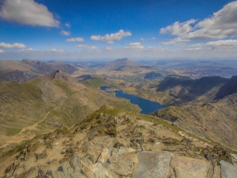
An astonishing spectacle of ethereal beauty, the 1,345 meter (4,411 feet) Ben Nevis mountain is undoubtedly Scotland's most remarkable crest. The highest mountain in the British Isles is perched along the lofty Highlands near Scotland's Fort William, an idyllic alpine town. Here it blends in with the majestic beauty of the Grampian Mountain ridge, attracting a stripe of experienced hikers and mountaineering enthusiasts every year. Resembling a stark Goliathan vision, the mountain was an active volcano millions of years ago that erupted and consequently caved in on itself, leaving in its wake fragments of pale granite that can still be seen today. Brilliantly shrouded in the mellow glow of the Scottish sun, the mountain features a magically colored gradient along its steep sides that becomes lighter as you reach the apex. The name Ben Nevis roughly translates into 'mountain with its head in the clouds' in Gaelic parlance, a profoundly apt description for this magnificent peak.
River Garry is a scenic river that is perfect for fishing; tourists and locals from all over head here to enjoy Salmon fishing.
The Corrieyairack Pass is simply a high pass in the Scottish Highlands. Rocky and gravelled at 770m (2526ft) high, no one would have known of this road had it not been for General Wade's military road built over it in 1731. Thus, if you would need to get to Fort Augustus from Laggan, you would require the services of this Pass. It was quite a hero in 1745 during the Jacobite Rising, however, today vehicles are advised not to traverse this path anymore.
Located around 19 kilometers (11.80 miles) to the eastern end of the historic Fort William, Stob a' Choire Mheadhoin stands tall at a height of 3625 feet (1105 meters) which makes it one of the tallest Munros in the region. Its neighbor, Stob Coire Easain is taller by merely 10 meters (32.80 feet). Hikers approach Stob a' Choire Mheadhoin from Fersit, a tiny hamlet nearby. Alternatively, one can climb its summit from the railway station at Corrour. The latter route is a longer one and requires a taxing hike.
Considered to be one of the most scenic ridge hikes in Scotland, Stob Choire Claurigh is found nearly 16 kilometers (10 miles) to the east of historic Fort William. For climbing the mountain directly, hikers start from the Corriechoille farmland area found close to Spean Bridge. Once at its peak, you get fascinating views of the tops and switchbacks of Grey Corries upland as well as Ben Nevis and Aonach Beag.
River Garry is a scenic river that is perfect for fishing; tourists and locals from all over head here to enjoy Salmon fishing.
The Corrieyairack Pass is simply a high pass in the Scottish Highlands. Rocky and gravelled at 770m (2526ft) high, no one would have known of this road had it not been for General Wade's military road built over it in 1731. Thus, if you would need to get to Fort Augustus from Laggan, you would require the services of this Pass. It was quite a hero in 1745 during the Jacobite Rising, however, today vehicles are advised not to traverse this path anymore.
The massif of Sow of Atholl is located on the west end of the Pass of Drumochter. A part of the Coire Dhomhain, this Scottish hill is sequestered from the other hills of its kind. Identified as a Corbett and a Marilyn mountain, this conical hill stands distinguished. The smooth, steep sloped of this hill are cloaked in vibrant heather. The inviting summit here proffers spellbinding vistas of the underlying pass, luring scores of mountaineers and hiking enthusiasts at its foothills.
Located around 19 kilometers (11.80 miles) to the eastern end of the historic Fort William, Stob a' Choire Mheadhoin stands tall at a height of 3625 feet (1105 meters) which makes it one of the tallest Munros in the region. Its neighbor, Stob Coire Easain is taller by merely 10 meters (32.80 feet). Hikers approach Stob a' Choire Mheadhoin from Fersit, a tiny hamlet nearby. Alternatively, one can climb its summit from the railway station at Corrour. The latter route is a longer one and requires a taxing hike.
Considered to be one of the most scenic ridge hikes in Scotland, Stob Choire Claurigh is found nearly 16 kilometers (10 miles) to the east of historic Fort William. For climbing the mountain directly, hikers start from the Corriechoille farmland area found close to Spean Bridge. Once at its peak, you get fascinating views of the tops and switchbacks of Grey Corries upland as well as Ben Nevis and Aonach Beag.
With an elevation of 3451 feet (1052 meters), Beinn a' Chaorainn is both a Marilyn and a Munro. Found on Glen Spean's northern end, Beinn a' Chaorainn remains a popular summit with hill climbers. The most favorite hiking route begins on A86 highway at Roughburn and car parking space is found at the dam of Loch Laggan. Once at its summit, hikers enjoy breathtaking views of the surrounding Munros which envelope Loch Treig.